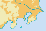
Urban Areas

Derived from 2002-2003 MODIS satellite data at 1 km resolution:
Schneider, A., M. A. Friedl, D. K. McIver, and C. E. Woodcock (2003) Mapping urban areas by fusing multiple sources of coarse resolution remotely sensed data. Photogrammetric Engineering and Remote Sensing, volume 69, pages 1377-1386.
(below) Japan is one of the most populated countries. View from Kyoto to Tokyo.

Issues
New version of the MODIS-derived urban area grid is now available (announcement, data download) at 0.5 km and uses an improved algorithm for better accuracy:
Schneider, A., M. A. Friedl and D. Potere (2009) A new map of global urban extent from MODIS data. Environmental Research Letters, volume 4, article 044003.
Schneider, A., M. A. Friedl and D. Potere (2009) Monitoring urban areas globally using MODIS 500m data: New methods and datasets based on urban ecoregions. Remote Sensing of Environment, in review.
No scale ranks. Missing just a couple polygons for points included in populated places.
Could be split apart (intersected with thiessen polygons derived from populated places points) and joined with populated places points to derive names and population values (and density).
Version History


[…] semi-transparent white ground on top of which all the other layers are displayed. Urban areas from Natural Earth both as a standalone layer and combined with Flickr shapefiles for cities and neighbourhoods. Road, […]
[…] como base de todas las capas. Después añaden información de áreas urbanas de la base de datos Natural Earth. Las carreteras y caminos corren por parte de la tan laureada plataforma de mapas colectivos […]
[…] maps out of things that people do, whether it’s geotagging photos or tracing streets or deriving urban areas from analysis of satellite photos, and posting his experiments with them as he goes. I’m zazzed (thanks AG) to announce that […]
[…] is me, test-linking Natural Earth so NVK can see the pingback. […]
[…] semi-transparent white ground on top of which all the other layers are displayed. Urban areas from Natural Earth both as a standalone layer and combined with Flickr shapefiles for cities and neighbourhoods. Road, […]
[…] semi-transparent white ground on top of which all the other layers are displayed. Urban areas from Natural Earth both as a standalone layer and combined with Flickr shapefiles for cities and neighbourhoods. Road, […]