New Cross Blended Hypso without Shaded Relief
 Due to popular demand, a new version of the Cross Blended Hypsometric Tints is available without relief shading. This allows the image to be used at scales other than 1:10M. The cartographer can then mix in their own scale appropriate relief shading.
Background: Cross-blended Hypsometric Tints offer a partial solution to a long-standing map reading problem: many people misidentify hypsometric tints (elevation colors) as vegetation or climate regions. Conventional hypsometric tints often show green in the lowlands, yellow in mid elevations, and red in the highlands. These map colors incorrectly suggest to the untutored that forests cover the parched Persian Gulf region and a hot desert climate prevails on the Greenland ice cap.
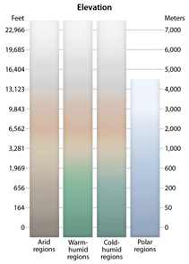
Cross-blended hypsometric tints instead use modified elevation colors for regions that people presumably associate with the natural environment. The Sahara is dusty brown, northern Russia is boreal forest green, the Mekong delta is jungle green, and Antarctica is icy blue-grey. As in nature, the map colors gradually blend into one another across regions (x and y axis) and from lowlands to highlands (z axis), hence the name cross-blended hypsometric tints. The legend above shows the map colors modulated by elevation and environment.


